|
|
 |
|
|
 |
|
|
|
|
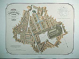
| Città di MIlano (Plan) |
Product code: 268 |
|
|
|
|
|
|
|
|
|
|
|
|
This map of Milan was drawn by Giacomo Pinchetti to a scale of 1:6200 on the basis of surveys carried out in 1788 by the Brera astronomical office. Of great importance to Milan’s history, the map boasts remarkable precision and draughtsmanship in the faithful definition of buildings, which even includes the columns of churches; owing to its accuracy it was referred to by later architects and planners (Cagnola, Canonica, Landriani, Albertolli, Zanoja) for the city’s Master Plan draughted in the Napoleonic era. The top key lists 29 public buildings and 69 churches; the bottom key carries the street names. The first edition of the map, printed in 1801, carried the Foro dell’Antolini in the castle area, a scheme never realized. The second edition (1808), reprinted by Vallardi in 1855, shows the urban fabric as it was and appears in the street list.
|
|
|
|
|
|
1984 anastatic reprint, 640 x 878, (565 x 790 copperpress).
Anastatic reprint 1:1 of 2nd edition published by Andrea Vallardi in 1808. Limited run of 500 numbered copies
italian, 160 g. Fabriano ivory-colored paper |
|
|
|
|
|
|
 |
|
|
|
|
Further proposals |
|
|
|
|
|
|
|
|
|
|
|
| | | |
|
|
|

| |
Milano Tecnica da...
|
|
|

| |
Nuova Piazza del ...
|
|
|
|
|
|
|
|
|
|
|
|
|
|


